The Jarbidge Traverse
The Jarbidge Mountain Traverse is ancillary to this story, and in fact the hours spent running versus the hours spent not running in the period which this story takes place is almost insignificant. Even though that’s the case, most stories from anybody revolve around the few hours spent in a heightened and purpose-driven curiosity rather than the mundane. My intention here is to fit the running part into the bigger picture, because the story as a whole is way better than the story of the particular “adventure” part. If you think about it, everything is an adventure if you make it one.
I began the journey as I typically do: driving east on I-80 from Reno. The last couple years I have made this drive more times than I can count; the great expanse of jumbled basins and mountain ranges harbor secret oases and an entire world of miners, prospectors, and ranchers seeking to capitalize on the abundant natural resources within them. It also harbors communities of people who live there for god knows why. All of this is unnoticed by the majority of people hustling through Nevada, Utah, Idaho, and Oregon just trying to blast through on the interstate to get somewhere they perceive as meaningful. Side story as an example: the town of Austin, Nevada lies along Highway 50, “the Loneliest Road in America” right in the center of the state. It’s way up in the Toiyabe Range, which is itself very worthy of visitation. High peaks, hot springs, deep canyons, thick forests, and of course, mining. My wife and I took a weekend trip through Austin to camp at one of the hot springs in the area, where we met a Jesus who was living in an old VW bug and subsisting on hot springs water and rice. As bakery connoisseurs and hungry people, we stopped into the only store open in Austin on the way back and were greeted by a gigantic lady with no teeth wearing some sort of clothing I have never seen before, who seemed genuinely surprised that anyone stepped inside of the building. The only thing for sale at the “bakery” were pre-packaged cookies, which she was actively eating. Piles of plastic wrapping lay on the table next to her, among discarded wooden furniture and trash that seemingly was leftover from the initial construction of the building in the 1860s. That is why nobody stops anywhere along Highway 50 besides gas stations.
Thanks for reading! Subscribe for free to receive new posts and support my work.
My career of choice (or really just happenstance) is hydrologist, which I’m not going to get into that deeply here. It basically just means I am responsible for finding good water for all the strange people of the Great Basin and Sierra Nevada regions. Preferably I do these work trips alone, because then I have autonomy over all the non-working parts. I still don’t know if I’m actually allowed by my employer to take side quests into the great beyond, but it’s my assumption that nobody in the corporate world has ever thought about exercising. Maybe that’s just me. So I blend into the office, talking about weather, and sports, and work projects, and clients, so as not to alert the powers that be to my shenanigans that take place along said work trips in the case that they mandate “no shenanigans on work trips.”
This trip combined two different projects, a spring survey for a potential lithium mine near Jackpot, Nevada and the removal of turbidity monitoring equipment near a reclaimed mine site in Jarbidge, Nevada. I headed out of Reno on a glorious early October Friday, north and east through sagebrush valleys burnt by the sun from the previous summer. Mountains towered in every direction, no obvious pattern for their placement. From the highway, every hill looks dry and desolate, places reserved for lizards and birds and nothing else. Podcast after podcast, song after song, I drove as all the others around me were, distracting themselves from our current place in life itching to get to the next. I was headed to the Knoll Mountains in northeastern Nevada, one of those apparent dead hills that highway-goers ignore.
Friday afternoon I got off the interstate at Wells, Nevada, another town consisting of hotels, gas stations, and people that I didn’t need to meet. Right above Wells is the East Humboldt Range, a mighty line of granite that also looks from afar like dead hillsides and whose elevated spine looks diminished in the scale of the Great Basin around it, which swallows it up in a dusty infinity that may not be beyond human comprehension. I drove up a long winding road, where mile by mile the range revealed its mysterious glory. Sweeping hillsides of peaking aspen forests on the northern slopes stood out from the dry towers and ridges of rock on the south faces. I stopped at a switchback marking a trailhead into the East Humboldt Wilderness, got out, and ran out to Winchell Lake, a small lake nestled into one of the canyons below Hole-in-the-Mountain-Peak, the highest peak in the range and one whose name-origin story is obvious. Not quite satisfied, I ran back to the car and then continued up to Smith Lake, a marvelous lake higher up in a glacial cirque and ringed by old Bristlecone pines. Even such an accessible area had almost no people in it, with the only people at the campground at Star Lake.


Winchell Lake and aspen grove on the way to it
Instead of exploring the thousands of peaks and lakes here, it was time to get to work on the project to satisfy the corporate overlords: a 160-site spring and seep survey, which I like to think of as a treasure hunt for water. Heading north from Wells towards Jackpot, I soon lost cell service and took a right on an unmarked dirt road and drove an unspeakable amount of miles into a vast nothingness towards a valley with some of the 160 spring sites. Places like this confront you with your aloneness. Quiet that you can’t experience anywhere, where you can stand in one place for a month and see not a soul. It was getting late, but I figured I’d knock out the visitation and documentation and sampling of some of the sites. The valley held several nasty, salty, scummy springs that only cows and ducks would ever utilize. I will withhold details of actual work in this essay because 1) It’s boring 2) It’s unnecessary 3) Typing is scary and 4) The locations and descriptions and history is more important. I found a spot to set up my tent next to a crippled little pinyon juniper, using it as company in the vast loneliness. Soon enough, a blanket of darkness settled over me, a darkness I can only compare to being inside of a cave. Pinpricks of star light emerged, increasingly freckling the sky until a shining parade of light shone from above. The great wheeling cosmos shone into the desert. As long as the written word has existed, people have been describing the mystery and existentialism of staring at the night sky, so I will refrain. I can only say that I got the same feeling, except now a glowing red and green came into the northern sky. Was I hallucinating? I didn’t know ahead of time, but the aurora borealis was visible all the way into the northern Nevada sky. This is what I was seeing, for the first time ever. I didn’t get the whole dancing green waves, but still…the glowing red and green sky was very cool.

The AURORA!
The next day I woke up and ran a workout on a dirt road into infinity, where Bureau of Land Management signs read “Furnace Canyon-70 miles” and “Tincup Reservoir-80 miles” and the like. Similar to geologic time, the scale of this place is not really comprehendible, even as a person who thinks about the world in terms of long distances running and biking. The entire rest of the day was spent driving to springs, doing the things I am supposed to do at said springs, and enjoying the sunshine. Later that night I drove into Jackpot, because I was meeting a coworker that was helping me with the survey the next few days and because the water samples had to be on ice.
Jackpot is weird. On the Idaho border, it attracts people that think their vacation time should be spent at Cactus Jack’s Casino. People walked around the casino, unaware that they were programmed through dopamine release to have purpose and happiness dependent on how many flashing lights they experienced all night. Blank eyes, dead stares, people that were less important to meet than the insane lady in Austin. My only interaction was on my final morning in Jackpot, after trying unsuccessfully to fill the sample coolers with a broken ice machine, a man emerged from his room with an empty bucket apparently requiring ice at 5 am. His anger was apparent through his dead eyes, hardened and enforced by his probable losses on the slot machines the entire night before. He briefly yelled at me and strode to the front desk to complain about me. I wish him the best.
Each morning I went on runs on dirt roads and two-tracks, getting lost and wading through waist-high icy creeks and jumping over fences. Each day my coworker and I drove up and down canyons and finding water sources. We admired geological formations, we marveled at fresh clear water pouring out of dry and crumbling hillsides, we inspected historical signs describing how early travelers used the water. We saw an ornery badger, a silent swooping Great Horned Owl, herds of antelope and deer. We hiked into deep canyons swollen with peaking aspens. We picked up crystals and cool rocks. We talked about things I cared about and he didn’t, things he cared about but I didn’t, and occasionally about things we both cared about. Slowly we covered the entire mountain range, experiencing the miracle of the Great Basin-that the dead hills seen from the roadways are actually hidden wonders of history, forests, water, wildlife, and loneliness that is heightened into a positive force relative to the loneliness of a car ride distracted by podcasts. Each night I half-heartedly completed mobility and strength workouts and called home to maintain the tenuous grasp on real life.
Finally we arrive at the part of the story related to the title. Jarbidge, Nevada, is one of the most remote “towns” in the lower 48, requiring a 3 hour drive from Jackpot or from Elko, with no pavement the last hour. From my understanding, it was founded as a gold mining town and was a haven for stagecoach robbers, before its inevitable demise into almost a ghost town. There are a few small historic sites including the old jail and a statue commemorating the townspeople’s fight against the Forest Service over control of the canyon. There is a country store that is always closed and a bar in which the locals spend the vast majority of their time. The name Jarbidge comes from the Shoshone “Jahabich,” meaning “devil.” The Shoshone thought that the mountains and canyons in the area were haunted, and they quite possibly were right.

Jarbidge
Driving from Jackpot in the early morning, now on my own again, I crossed into Idaho and out of the geological Great Basin. There was a certain change in feeling that I can’t describe, as if the final destination of the water around me actually mattered to the energy impacting my senses. Idyllic and lonely ranchland lie in every direction, and the Jarbidge Mountains in the distance drew my attention. Soon enough I hit the end of the pavement, and the road careened down a canyon. To my left was a gaping fissure in the earth, a canyon emanating from the heights of the mountains above and impatiently pointing straight down to Murphy Hot Spring, Idaho, the last community before Jarbidge and one I’ve been told not to stop in. I don’t have anything against Mormons, but the specific breed of them up here are the type with many wives, survivalist and racist beliefs, and who only exist in this beautiful place because its far out of the reach of the Sheriff’s jurisdiction. So I kept driving, now in the base of the canyon and following the Jarbidge River upstream. It was October, so the river was a fraction of the flow it is in the spring and summer; however, it was apparent that over the years the water was powerful enough to carve out canyons as deep as the well-known paradises in Utah and Arizona. Walls towered all around me, and now the world changed into forests of fir, aspen, and cottonwood, more reminiscent of Colorado or New Mexico than Nevada.
I spent the morning driving the most ferocious four-wheel-drive roads that seemed to rise vertically in and out of every drainage, covered in microwave-sized rocks and fallen aspen trees. I went out and found turbidity monitoring equipment in the creeks way up high but below the big reclaimed gold mine, lugging it back to the truck, and thinking about the route I was trying to get done later. Somehow my tires didn’t explode, I didn’t roll off a cliff, and I made it back to Jarbidge itself. I wanted to soak in the aura of the town a little bit, but I didn’t really have that much time before 1) it got dark and 2) a big scary storm was scheduled to come in, just in time to finish all the field projects on the trip. I had perused the maps of the area on Gaia, immediately drawn to a perfect loop encompassing the six peaks above 10,000 feet on one ridgeline, with a descent following the Jarbidge River from its headwaters at Jarbidge Lake to the campground where the loop began. There are a million other very worthwhile loops in the area, but the “Skyline Traverse” rearing above me was too enticing to ignore.
I threw on shoes, some random layers, some snacks lying around in the back of the truck. Then I just started. My favorite thing about loops like this is the mystery, the challenge of whether or not you’ll complete it as intended. There is no fanfare or pressure or even thought of performance-based outcome, just the wild mountains and the subtle awareness that there may be a storm coming soon. I started running up an old mining road, one like the ones I was crawling over in a truck earlier that day. South-facing slopes were dry and brushy, large fingers of mountain mahogany reaching into the road. Not that picturesque of a plant, but the best firewood in the galaxy. Switchbacking up the side of the canyon, I soon crossed onto a northern-facing slope and was thrust into a thick forest of fir trees, with a view of my first objective far above me.

Jarbidge Peak on the climb out of Jarbidge River canyon
I hold on to the hope that Gaia and other maps know what they’re talking about, even though I’ve been misled more times than I can count. In this case, the road ended at an abandoned mineshaft and the trail on the maps up the ridgeline did not exist. Then ensued a horrendously crumbly ascent through the thinning trees and rock bands up 2500 feet in a mile and a half, the summit seemingly never getting closer. Eventually I clambered onto the broad summit of Jarbidge Peak, the expanse around me opening up into a yawning wilderness of peaks, valleys, forests, rocks, and mysteries that stretched beyond eyesight. Of course, there were no people in sight but to my surprise there was a mailbox as a summit register and a large wooden sign signifying the peak. The summit register even listed someone visiting the peak a month prior, which simultaneously made me grumble with feelings that the peaks weren’t quite as un-visited as I thought and with a soft feeling of safety, that someone had been up here and the route was achievable.


Jarbidge Peak Summit Register
The objective line of mountains sprawled in front of me, as the sun disappeared beneath a monotonous gray sky and a stiff breeze rose from the north. Better get going. Again, the imaginary trails on the ridgeline did not exist in reality, so I “ran” down to the next saddle through broken orange rocks littering the mountain and hiked up the impressive ridgeline to Jumbo Peak. In quick succession were Square Top Peak and Matterhorn Peak, both of which looked almost identical to Jumbo Peak. Matterhorn was the highest point on the ridgeline at 10,838’, and the ascent up the sweeping and sharp ridge was impressive. Each successive peak brought me further and further into the Jarbidge Wilderness area, and the views got more and more outrageous. Idaho, Nevada, Utah maybe? Canyons and peaks rising out of the deserts below.


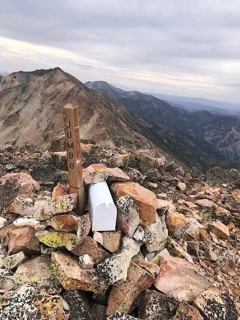


Headed to Jumbo Peak, Jumbo Peak, headed to Square Top Peak, Square Top Peak, headed to Matterhorn Peak, Matterhorn Peak. You get the idea.
Standing on Matterhorn Peak is the feeling I was looking for. Solidly in the middle of nowhere, with nobody and nothing around to hear me, new and unique and maybe haunted mountains all around me. Accompanying it was a little bit of stress, because I discovered that my headlamp was dead and the extreme slowness of the route meant that there was no way I would be done before dark. I tried to hustle to complete the ridgeline and cross a trail that I was sure to actually exist, but the next section was interminable. Steep crumbling rock off the summit led to a ridgeline that when viewed from above looked almost whimsical, but in actuality was a knife of rock studded with gnarled fir trees that required awkwardly slow movements to get through. Cougar Peak reared above, the next pile of rock to ascend and descend. It seemed to take an hour to crawl my way there, and from the summit I saw thick clouds, fog oozing its way up from the valleys in every direction and strangling my sense of direction. My final summit was a small one, Government Peak, (undoubtedly the townspeople want a smaller government) but I could only see it for a minute before it was swallowed in the mist. Another frustratingly slow ridgeline choked with firs, another miraculous ascent and descent, and I stepped onto a TRAIL in the dying light.


The ridgeline to Cougar Peak, its summit, and the last view of Government Peak
Unfortunately I have no photos of the descent down the canyon. My knowledge of the impending darkness precluded my use of my phone, knowing it would be only source of light for the last hour or so. You’ll just have to take my word for it: the trail down the Jarbidge River is amazing. Thick fir and aspen forests, creeks at every turn, even in October, rock walls randomly rising out of the forests, and again a sense of loneliness that I view as spiritual. Down and down and down I went, gradually losing the elevation I had earned so suddenly at the beginning of the loop. The mist kept the forest even more mysterious than it would be in the sunshine, and then it began to rain softly. Suffocating darkness closed in, and I finally gave up trying to speed up human evolution to be able to see in the dark. My dying phone, at 4% battery, somehow escorted me all the way down the canyon to the campground and died at the exact moment I unlocked the truck. Hauntings can be benevolent I guess.
It’s customary in trail running culture to throw on a trucker hat, stretch out the legs while sitting on a cooler of craft IPA, and gossip about Jim Walmsley after a run like this. But the storm was starting, and I had to get over the pass to Elko before the snow closed it down. A day that began driving in the dark through Idaho ended driving in the dark and thick fog in Nevada, up and over endless winding dirt roads through what I imagine were very pretty forests. Hours passed and I made it down to the sagebrush, solidly back in the Great Basin. Rain pounded the windshield. In a fit of manic exhaustion, I threw up a tent somewhere that I will never be able to identify and fell asleep.
Back to Reno the next day, trip complete. My wild animal soul was satisfied, at least for the time being.